SUPPORTING NATURAL CAPITAL ACCOUNTING
Mapping natural capital assets and ecosystem services.
The Ecosystem Intelligence Platform (EI) provides a comprehensive GIS and data analytics solution that can be used in the development and maintenance of ecosystem stock and flow accounts in accordance with the System of Environmental Economic Accounting - Ecosystem Accounting (SEEA EA) framework.¹

Graphic from Czúcz et al. 2021.
Paired with our Partner systems, it is part of an integrated suite of tools for SEEA ES, Corporate Natural Capital Accounting (CNCA) and biodiversity accounting. Presently, EI provides fully and semi-automated modules that build ecosystem asset accounts and measure final ecosystem services.
EI supports users implement the basic steps of SEEA EA (and other accounting frameworks). In general, they are:
Ecosystem Extent and Condition
Collect Site Characteristics or Attributes
Identify Natural Assets
Define the Ecosystem Accounting Area
Determine Ecosystem Extent
Measure Ecosystem Condition and Characteristics
Ecosystem Services Flows
Measure Ecosystem Service Flow
Identify User and Use (performed by EMX project partners using EI outputs)
Assign Economic Values (performed by EMX project partners using EI outputs)
Calculate Value of Natural Assets (performed by EMX project partners using EI outputs)
Additionally, EI provides:
A Dashboard for portfolio and data management
Presentation and reporting support (providing outputs to EMX project partners for reports/presentations)
Ecosystem Extent and Condition
Collect Site Characteristics or Attributes
Site Accounting
SEEA EA/CNCA Method Step
Building ecosystem accounts requires capturing data from public data sets (e.g., precipitation, typography), satellite imagery and field observations. SEEA encourages the use of best practices.
EI Compatible Feature/Process
Utilizing either the desktop or field app, EI provides field ecologists an easy-to-use GIS based data entry process that is directly linked to the broader platform. It enables collection of ecosystem characteristics or attributes for measuring Ecosystem Integrity and flows of ecosystem services and facilitates the incorporation of public data sets and satellite imagery.
Identifying Natural Assets
Define the NCA Ecosystem Accounting Area
SEEA EA/CNCA Method Step
The initial step in developing natural capital accounts is to create the ecosystem accounting area unit (EAU). This is a spatial boundary that defines the geographic extent of the area relevant for analysis and reporting purposes.
EI Compatible Feature/Process
Within the EI spatial data structure, the EI’s Analysis Area (AA) serves as geographic extent for all analysis and reporting.
Determine Ecosystem Extent
SEEA EA Method Step
Once the EAU boundary is established, the next step is to partition this area into the discrete ecosystem types that are present. This is normally done according to a global land cover or ecosystem standard, such as the IUCN Global Ecosystem Typology (GET).
EI Compatible Feature/Process
EI delineates the AA into discrete habitat types. These habitat types correspond to the ecosystem types in the IUCN GET and similar classification systems. Within the EI terminology, the individual habitat type unit is referred to as a Survey Unit. The development of Survey Units is very flexible as EI’s ecosystem models are powered by the on-the-ground characteristics of these habitats. Due to this, EI Survey Units can be developed according to any land cover/land use convention or ecosystem typology.
Determine Ecosystem Condition
SEEA EA Method Step
The determination of ecosystem condition involves two stages. The first stage is the determination of characteristics and indicators of condition based on scientific research and should reflect the current on-the-ground state. The second stage concerns the comparison of the characteristics and indicators to a common reference condition.
EI Compatible Feature/Process
The data inputs (data sets and field collected characteristics) for EI are based on scientific literature and 20+ years of subject matter expert engagement.
EI’s data inputs consist of measurable attributes that cover a variety of characteristics of the landscape such as: vegetative structure, soil composition, water regime, and topography. In terms of the SEEA Ecosystem Condition Typology (ECT), EI data inputs consist of abiotic, biotic and landscape level ecosystem characteristics. Examples of EI data inputs are:
Class A1 - Physical state characteristics
Surface soil composition
Impervious surface area
Soil compactness
Water availability (water regime/duration)
Class BI - Compositional state characteristics
Vegetation species richness
Class B2 - Structural state characteristics
Vegetation composition (dominant and by strata)
Canopy cover
Ground cover
Leaf litter/organic material
Snags/down wood/large wood
Class C1 - Landscape and seascape characteristics
Microtopography
Slope/gradient
Proximity to threats/stressors
Using these data inputs, EI employs 52 distinct models to evaluate a variety of ecosystem processes. These ecosystem functions are equivalent to the Class B3 - Functional state characteristics in the SEEA ECT. Examples of EI modeled ecosystem processes are:
Class B3 - Functional state characteristics
Biodiversity
Pollinator support
Nitrogen storage
Organic matter production
Evaporation
Filtration
Using this ecosystem condition characteristic data, EI models an Ecosystem Integrity Score. The Ecosystem Integrity Score is benchmarked to a highly functioning (intact) reference condition for each ecosystem type. It represents the intrinsic value of an area, and, less directly, its instrumental value and resilience.²
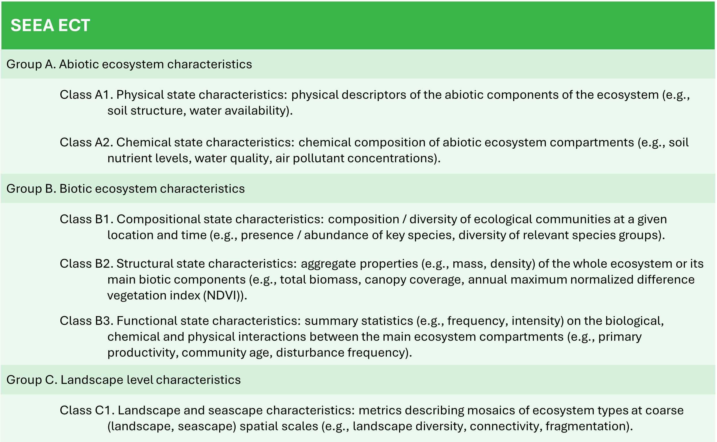
Table reproduced from United Nations et al. 2024.
Ecosystem Services Flows
Measuring Ecosystem Services
Assessing Ecosystem Service Flows
SEEA EA Method Step
SEEA EA recommends that ecosystem accounts should be comprehensive and include as many types of ecosystem services as possible. While several ecosystem classification systems have been developed (e.g. the Common International Classification of Ecosystem Services (CICES) and the National Ecosystem Services Classification System (NESCS Plus)), no standardized international classification of ecosystem services currently exists. SEEA recommends a classification they have developed based on the CICES and NESCS Plus classifications and has developed its own list that crosswalks to CICES and NESCS.
SEEA EA states that ecosystem services should be quantified in terms of measurable units relative to the service provided. Both biophysical units and standardized units of measure are acceptable.
EI Compatible Feature/Process
EI’s Engineering Units are equivalent to ecosystem services flows in accounting. Automated modules produce flow units for air quality, water quantity and water quality. Semi-automated models exist for heat mitigation, recreation and cultural appreciation. Additional ecosystem services modules are being automated and can be provided on request.
References
¹ United Nations et al. 2024. System of Environmental-Economic Accounting - Ecosystem Accounting. Available at: https://seea.un.org/ecosystem-accounting
² Keith, H., Maes, J., Czúcz, B., Jackson, B., Driver, A., Bland, L., Nicholson, E. 2019. Discussion paper 2.1: Purpose and role of ecosystem condition accounts. Paper submitted to the SEEA EEA Technical Committee as input to the revision of the technical recommendations in support of the System on Environmental-Economic Accounting. Version 5 Available online at https://seea.un.org/sites/seea.un.org/files/documents/EA/seea_ea_f124_web_12dec24.pdf
³ Czúcz, B., H. Keith, J. Maes, A. Driver, B. Jackson, E. Nicholson, and C. Obst. 2021. Selection criteria for ecosystem condition indicators. Ecological Indicators 133. Available at https://doi.org/10.1016/j.ecolind.2021.108376
For additional information on natural capital accounting, see:
Biological Diversity Protocol, CSIRO Natural Capital Handbook, Time to Take Stock, BSI 8632:2021 Natural Capital Accounting for Organizations, and ISO 14054 Natural capital accounting for organizations.
'%3e%3cg id='Final-Copy-2_2_' transform='translate(1275.000000, 200.000000)'%3e%3cpath class='st0' d='M7.4,12.8h6.8l3.1-11.6H7.4C4.2,1.2,1.6,3.8,1.6,7S4.2,12.8,7.4,12.8z'/%3e%3c/g%3e%3c/g%3e%3c/g%3e%3cg id='final---dec.11-2020'%3e%3cg id='_x30_208-our-toggle' transform='translate(-1275.000000, -200.000000)'%3e%3cg id='Final-Copy-2' transform='translate(1275.000000, 200.000000)'%3e%3cpath class='st1' d='M22.6,0H7.4c-3.9,0-7,3.1-7,7s3.1,7,7,7h15.2c3.9,0,7-3.1,7-7S26.4,0,22.6,0z M1.6,7c0-3.2,2.6-5.8,5.8-5.8 h9.9l-3.1,11.6H7.4C4.2,12.8,1.6,10.2,1.6,7z'/%3e%3cpath id='x' class='st2' d='M24.6,4c0.2,0.2,0.2,0.6,0,0.8l0,0L22.5,7l2.2,2.2c0.2,0.2,0.2,0.6,0,0.8c-0.2,0.2-0.6,0.2-0.8,0 l0,0l-2.2-2.2L19.5,10c-0.2,0.2-0.6,0.2-0.8,0c-0.2-0.2-0.2-0.6,0-0.8l0,0L20.8,7l-2.2-2.2c-0.2-0.2-0.2-0.6,0-0.8 c0.2-0.2,0.6-0.2,0.8,0l0,0l2.2,2.2L23.8,4C24,3.8,24.4,3.8,24.6,4z'/%3e%3cpath id='y' class='st3' d='M12.7,4.1c0.2,0.2,0.3,0.6,0.1,0.8l0,0L8.6,9.8C8.5,9.9,8.4,10,8.3,10c-0.2,0.1-0.5,0.1-0.7-0.1l0,0 L5.4,7.7c-0.2-0.2-0.2-0.6,0-0.8c0.2-0.2,0.6-0.2,0.8,0l0,0L8,8.6l3.8-4.5C12,3.9,12.4,3.9,12.7,4.1z'/%3e%3c/g%3e%3c/g%3e%3c/g%3e%3c/g%3e%3c/svg%3e) Your Privacy Choices
Notice at Collection
Your Privacy Choices
Notice at Collection